Home / Benchmarking / Fire: flame length

Fire: flame length

Identifies where severe fire later occurred with consistent skill across the whole 39-year record, and shows an ecologically plausible fuel build-up in undisturbed forest.

Layer Fire_ELMFire_FL 3 evidence axes v2026.1

What was compared

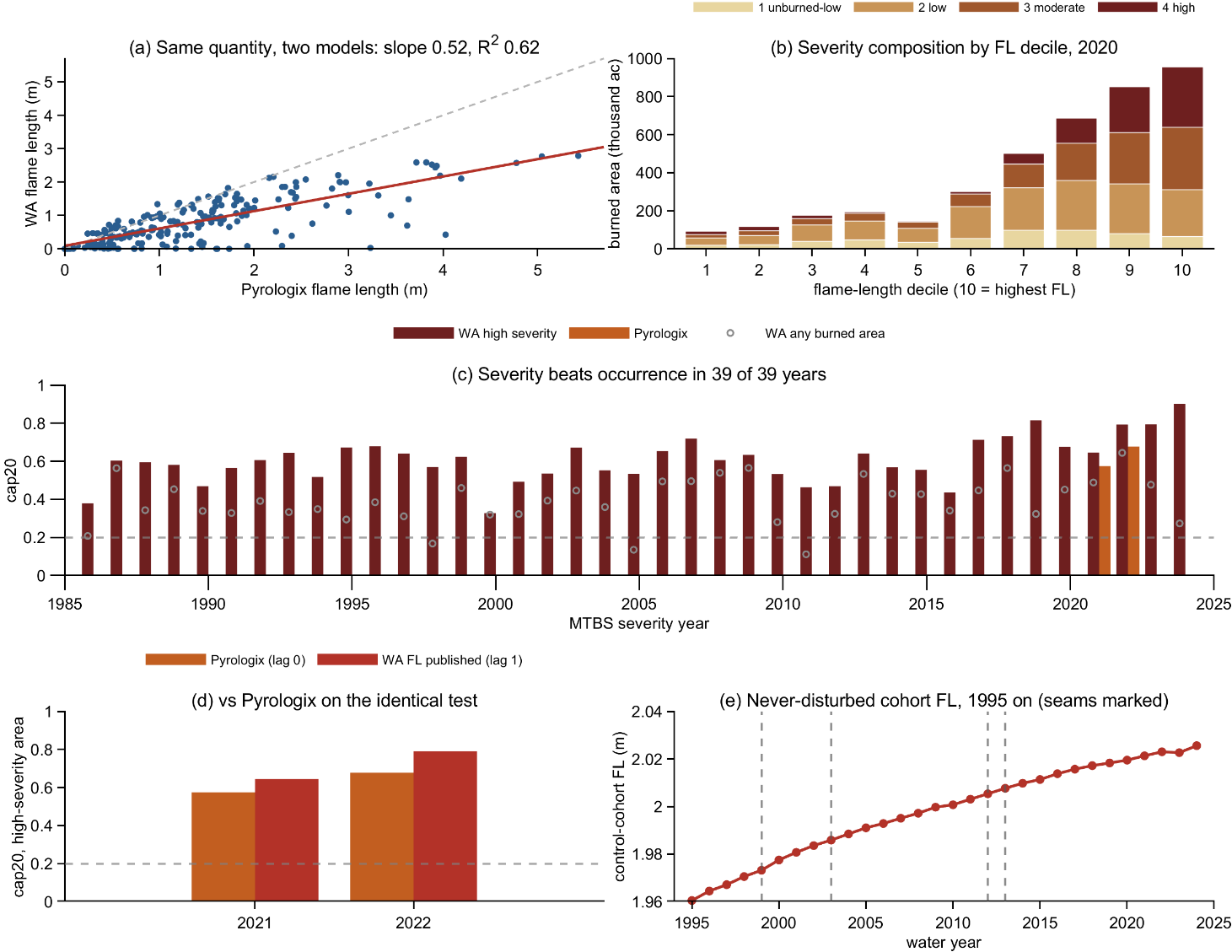
Fire: flame length benchmarking figure: multi-panel comparison of Wildland Almanac against reference data.
Benchmarking panels for fire: flame length, from WildlandAlmanac_CA_QualityBenchmarks.pdf (v2026.1). Panel letters below correspond to the panels above.

a  WA flame length against Pyrologix, a published commercial model, for the same places. Same pattern (R² 0.62); WA reads lower because it uses a different crown-fire model.

b  How severely fires actually burned, grouped by WA's predicted flame length. Severe area climbs steeply from the lowest tenth to the highest.

c  Each year 1986-2024: the share of severely burned area falling in the top 20% of predicted flame length. Above chance (0.20) in all 39 years, and always better than predicting from burned area alone.

d  The same test applied to WA and to Pyrologix, for the two years Pyrologix covers, so the two are scored identically.

e  Average WA flame length 1995-2024 for forest never disturbed. Gradual, ecologically plausible fuel build-up with no jumps at the Landsat changeovers.

Evidence

Strengths and weaknesses on each axis, as measured. Weaknesses are stated at the same level of detail as strengths.

AxisStrengthsWeaknesses
External skillA clear relationship between predicted flame length and subsequent high-severity fire, with cap20 of 0.61 - that is, 61% of severe fire occurs in pixels that were in the top 20% of predicted flame length the previous year [c]. Skill is consistent across the whole 40-year record: cap20 averages 0.605, exceeding random by more than 200%, with little or no degradation back to the 1980s.Not all fuel classes behave alike. GR, GS and TL match or beat the pooled 0.61 within class, but SH and TU fall to 0.28-0.42. The layers use weighted weather reflecting local climatology and do not consider local ignition probability; they are not predictions of severity for any specific fire, where weather variation is a strong driver.
Internal coherenceUndisturbed-cohort flame length rises 3.2% across the record, 1.93 to 1.99 m (+0.0024 m/yr), reflecting gradual and ecologically plausible fuel build-up [e]. Landsat transitions are clean, with no step changes or inflections.—
Cross-dataset consistencyGood agreement with contemporaneous Pyrologix flame length (R² 0.62) [a]. Both are also scored against subsequent severe fire on the identical test, for the two years Pyrologix covers [c, d] — the figure shows the result.The magnitude difference against Pyrologix likely reflects contrasting crown-fire models - WA uses ELMFIRE's Cruz algorithm, which yields lower flame lengths than the Scott parameterisation Pyrologix uses. So the level is not directly comparable even though the pattern and the skill are.
Synthesis.
High confidence  Identifies pixels at elevated risk of high-severity fire, and tracks them precisely for four decades

Lower confidence  Weaker within shrub and timber-understory fuel classes

Specifics

WA flame length is a conditional climatology - what would burn if a fire arrived under typical local weather, not a forecast for any particular fire. References: Pyrologix (2021-2022) and MTBS thematic severity 1984-2024.